
Tampa, FL, August 11th, 2026–Written by Nick Cannella
Manatee County land development is accelerating in the Parrish corridor, and a newly funded I-75 interchange at Fort Hamer is the reason — when a funded interchange lands on the map, every parcel within a few miles gets repriced.
The state budget signed in June includes $5 million to design a new I-75 interchange where a northern extension of Fort Hamer Road would cross the interstate in south Hillsborough County, just above the Manatee line. In our work across this corridor, we have watched this exact pattern play out before — and the landowners who understand their position early are the ones who do best.
This post explains what the interchange means, why it changes land values, and where the window of opportunity sits right now.
What Fort Hamer Road has already done
To understand the impact of the interchange, look at what the corridor has already produced.
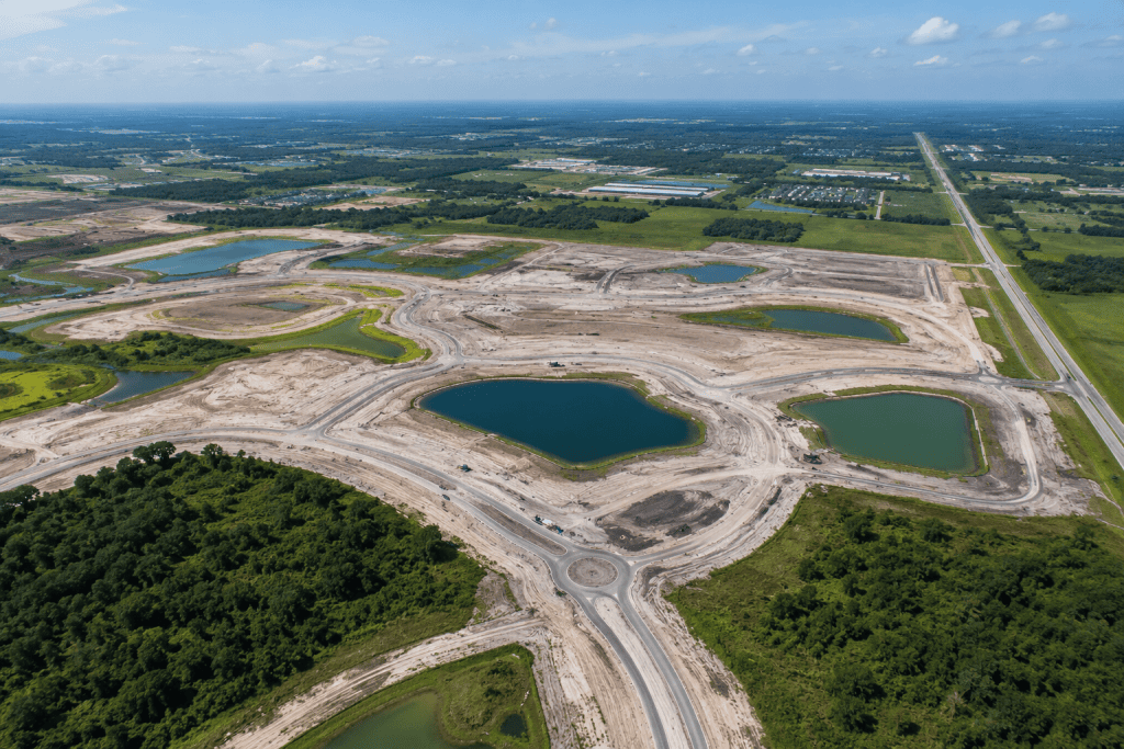
When Manatee County and Neal Land & Neighborhoods opened the 3.65-mile Fort Hamer Road extension from US-301 past Moccasin Wallow Road in 2023, it unlocked the Parrish corridor almost overnight. North River Ranch now has approvals for more than 5,000 homes. Market Walk opened with a Publix anchor. HCA built a freestanding ER planned to grow into a hospital of more than 150 beds. State College of Florida received funding for a Parrish campus.
Retail follows rooftops, and rooftops follow roads. The corridor’s transformation is a case study in how infrastructure drives land value.
Why an interchange reprices everything around it
An interchange changes the math again — and the numbers from this corridor make it concrete.
At the existing Moccasin Wallow exit, the entitled mixed-use quadrants were reported all sold, under contract, or pending by spring of last year. This May, Del Webb closed on just over 400 acres at North River Ranch for nearly $39 million — roughly $95,000 per acre for entitled land.
That is what proximity to interstate access does to land value. When a funded interchange enters the picture, parcels that were priced as speculative agricultural ground begin to be underwritten as future development sites.
Where the opportunity sits now
The bigger opportunity sits on the Hillsborough side of the county line.
The ground between the county line and SR-674 around Ruskin and Wimauma remains largely agricultural, and rezonings tied to the interchange have not yet appeared there. That is the window. Once the feasibility study becomes a PD&E study and design produces right-of-way maps, the pattern that played out in Parrish will repeat to the north.
FDOT District Seven has an active feasibility study underway on the segment between the county line and Valroy Road near Ruskin, and reporting on the funding documents indicates construction could begin as early as 2028. The owners who understand their position early — before rezonings arrive — are positioned to do best.
A note of caution
Infrastructure momentum does not guarantee a smooth path to entitlement.
In February, Manatee commissioners unanimously denied Lennar’s 683-acre Lone Valley rezoning between I-75 and Fort Hamer Road, citing infrastructure and a lack of commercial services. Boards on both sides of the county line want roads in place before entitlements — which is exactly why an interchange with real design money behind it is such a strong signal.
For landowners, the lesson is that timing and preparation matter. Understanding how Florida’s Comprehensive Plan works and what developers look for before making an offer is the difference between reacting to the market and getting ahead of it.
What Manatee County land development means for landowners
If you own land between the Manatee county line and Ruskin, this is the window — before rezonings arrive and before the interchange design is finalized.
The value inflection tied to a funded interchange happens in stages: feasibility study, PD&E study, right-of-way maps, then rezonings. Each stage reduces uncertainty and adds value. Owners who understand where their parcel sits in that sequence can make far better decisions than those who wait for an offer to tell them.
If you own land in this corridor, our Southwest Florida land advisory team can help you understand what you have and where it sits in the timeline. You can also view available land listings across the region. When it comes to Manatee County land development, the time to understand your position is now — not after the maps are drawn.
Own land between the county line and Ruskin? This is the window, before rezonings arrive. Contact Eshenbaugh Land Company.